SAND Geophysics.
What services can SAND provide for your project.
Lorem ipsum dolor sit amet, consectetur adipiscing elit, sed do eiusmod tempor incididunt ut labore et dolore magna aliqua. Ut enim ad minim veniam, quis nostrud exercitation ullamco laboris nisi ut aliquip ex ea commodo consequat.
Surveying services.
DEDICATED TO SURVEYING AND CONSULTANCY.
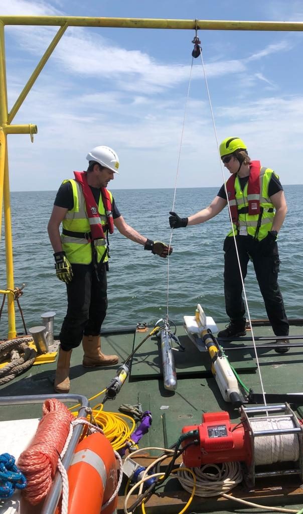
We specialise in high-resolution seismic, sidecan and magnetometer survey’s. We also provide personnel for offshore acquisition, processing, interpretation and reporting. If you want your project monitored with reliable quality assurance we can provide offshore party chiefs or client representation that will follow the project from start to finish.
Trained personnel.
SAND Geophysics can provide fully qualified and experienced personnel for:
All our geophysicists are trained and experienced with a wide range of software and equipment ensuring seamless integration to the project team. We can supply our personnel with a high-spec processing laptop and software on request.
Our project managers have experience in managing the technical, logistical and commercial aspects of geophysical projects and are well versed in leading large multi-disciplinary teams.
Our party chief are experts in coordinating geophysical and AUV surveys, specialising in shallow water and high risk projects.
As client representatives you can be sure that we are providing a good level of QC offshore and we also provide QC of the finished reports and final deliverables.
Consultancy & data processing.
SAND specialise in UXO and Chirp datasets.
SAND Geophysics specialise in marine high-resolution shallow geophysical techniques. Our core personnel have extensive academic and industry experience in providing both off-the-shelf and bespoke project solutions, specialising in high-resolution seismic and unexploded ordnance (UXO) detection.
SAND can provide consultancy assistance at any stage of a project or phase of the development cycle. We can provide expertise in pre-installation site surveys for UXO ALARP and/or route planning, engineering design site surveys for infrastructure design, and post-installation inspection and/or monitoring.
Within this, our input can range from assisting with survey planning and specifications, preparation and/or review of tenders through to data review, quality control, data integration and presentation of results.
SAND can provide contract geophysical data processing, interpretation and presentation solutions for a wide range of data sets including: potential fields (Magnetometer/Gradiometer) sidescan sonar, seismic reflection and refraction, bathymetric (including backscatter) and acoustic ground discrimination systems.
Alongside bespoke in-house software, SAND utilise a wide range of industry standard systems, including: Geosoft Oasis Montaj, CODA, DUG Insight, Kingdom Suite, ProMAX, SonarWiz, QINSy, RadExPro, GeoSuite, Petrel, ESRI and many more, ensuring we can handle any datasets.
SAND understand that the most important aspect of data handling is ensuring that the results are accessible by and understandable to the end user, be that engineers, designers, environmentalists or other stakeholders.
SAND can integrate data from multiple systems or surveys and provide results in a range of formats from paper charts and reports to interactive 3D models and web-based databases making your data more accessible than ever before.
Research & survey.
SAND Geophysics can provide tailored survey solutions for any marine geophysical projects.
SAND can provide high resolution sub-bottom profiling survey’s utilising a number of sources:
All data can be provided in raw or processed industry standard formats and SAND can provide professional interpretations to provide the relevant information for your project.
Specialising in Chirp surveys our expertise in acquiring and processing raw CHIRP data enables us to detect smaller features such as buried pipelines and cables more effectively than standard black-box processing techniques.
SAND can provide ultra-high resolution multi-channel seismic surveys which allow for a significantly improved signal to noise ratio and the removal of seabed multiples. SAND Geophysics utilize specialist high resolution streamers alongside sources which provide the frequency spectrums required for high resolution data SAND can obtain accurate depths and sub-surface geometries.
Using the latest research and experienced data processors SAND Geophysics can calculate acoustic velocities and undertake sediment characterisation increasing the information available from a single survey.
SAND specialise in the use of multiple sensor survey arrays for Unexploded Ordnance (UXO) or debris detections surveys, however data can also be interpreted for geological features. We can provide complete management of debris clearance or UXO surveys from survey design through to data reporting. Working alongside the top industry explosive ordnance disposal (EOD) and risk management specialists we can provide UXO clearance or As Low As Reasonably Practicable (ALARP) certification to enable the safe execution of future seabed interactions. To ensure successful projects all our survey solutions are designed on a project by project basis following a review of the threat items and site conditions.
Working alongside the University of Southampton SAND are proud to be the first commercial provider of 3D-Chirp survey technology.
Ideally suited for object detection and acoustic sediment characterisation the GeoChirp 3D has been developed by the University of Southampton over the past 10 years and is now manufactured by Kongsberg. It is the only decimetre resolution true 3D seismic survey system available and the system has a proven capability to detect buried debris down to 20 cm diameter. The system can provide precise burial depths, object dimensions and now through specialist processing and interpretation techniques it is possible to differentiate between different materials.
For more information on the capabilities of the system please contact us or see the University of Southampton 3D-Chirp website.
SAND can provide a range of sidescan sonar survey capabilities to suit any project from low frequency wide area survey systems right through to high frequency search and recovery (SAR) systems.
Data can be processed to provide seabed characterisation or habitat maps, as well as for seabed target identification. All data can be provided in raw and/or processed industry standard formats and interpretation reports can be tailored to client requirements.
Alongside our core survey expertise SAND can provide a number of additional services to ensure a complete package if required. These include: Survey Positioning, Multibeam Bathymetry (including backscatter), single beam bathymetry, current profiling (ADCP), Acoustic Ground Discrimination (AGDS) etc.
Development & training.
SAND can provide training for:
Research & development.
Innovating & developing.
Innovation is at the core of SANDs working philosophy, continually pushing the boundaries of what is possible to develop novel solutions for complex and challenging marine near-surface problems.
At the corporate-level, SAND has strong ties with the several UK universities, most notably the University of Southampton. SAND currently co-funds two PhD projects through the University of Southampton (on 4D imaging and UXO discrimination) as well as working closely with various members of the Ocean and Earth Sciences staff on the continued development of 3D Chirp.
At the personnel-level, SAND staff have extensive experience in undertaking research and development, both within the academic and industry sectors. The outputs from these projects have been published in the highest-level peer-reviewed academic journals and won awards at conferences, whilst simultaneously maintaining a focus on remaining commercially viable solutions.
Dr Mark Vardy has supervised 5 PhD students, authored or co-authored over 20 peer-reviewed publications, is an Associate Editor for Near Surface Geophysics, and has developed/applied a range of novel high-resolution marine acquisition and processing methodologies. He was a co-developer of the first commercial decimetre-resolution 3D seismic system, has written numerous seismic processing algorithms (e.g., frequency-approximated Kirchhoff imaging, geotechnical inversion), and has consulted on a range of research projects, from understanding river evolution in Bangladesh to mapping the edifice collapse deposits around Montserrat. Within SAND, Mark’s primary focus is the continued development of our in-house QSI software.
Click here for more information on seismic inversion.

Dr Luke Pinson has published over 10 peer-reviewed publications and presented his research findings at conferences all over the World. His principle area of expertise is developing ground breaking new seismic techniques, particularly around linking the acoustic and rock physical properties. His 2008 paper on seismic attenuation was awarded a commendation by the journal Geophysics, narrowly missing out on winning the prestigious Best Paper in Geophysics prize. Technically, he has worked extensively on the commercial development of AUVs for application in the Oil and Gas sector.
Richard Hamilton specialises in the implementation of new technologies, leading the development of new industry standard UXO survey methods. In particular, he has worked on improving the robustness of pUXO classification through the optimal acquisition and integrated interpretation of multi-sensor arrays, reducing the number of targets requiring mitigation and/or inspection.
Please contact us if you have a research project SAND can help with.
Seismic imaging & inversion.
SAND’s robust processing system is now available for all clients.
SAND has developed a family of seismic processing and inversion algorithms specifically tuned for application to high-frequency, marine near-surface seismic reflection data. Broadly these are grouped into two software suites, QSI and QSI-3D, which deal with 2D and 3D data, respectively.
The software includes bespoke imaging algorithms that have been developed to maximise the penetration and resolution of a variety of UHR marine seismic reflection data. These include algorithms capable of handling the irregular spatial sampling, high frequency content, and contamination by coherent noise (specifically source/receiver ghosts and seafloor multiples). Time and depth imaging versions are available.
However, by far the most novel component of QSI are a family of seismic inversion codes that use the amplitude, phase, and frequency content of seismic reflection data to derive quantitative information regarding the nature of the seabed and near-surface sediments. A range of different machine learning approaches can be applied, depending on the data/project requirements, permitting both bulk physical properties (e.g., P-wave velocity, bulk density, and porosity) as well as more advanced geotechnical properties (e.g., undrained shear strength, relative density, and soil classification) to be derived and mapped at a resolution controlled by the geophysical data.
These algorithms have been successfully applied to a broad spectrum of UHR marine seismic data, including Chirp, Boomer, Sparker, and Airgun sources. All inversion algorithms are cast within a stochastic framework, allowing property envelopes (i.e., 95% confidence estimates) to be provided as well as ‘best’ estimate solutions.