SAND maximises geophysical data with advanced processing to deliver detailed subsurface ground models for diverse industry applications.
Ground Modelling Services
Generic, industry standard analyses often fail to fully realise the potential of geophysical datasets. Using SAND’s advanced QSI processing suite, each dataset can be maximised to provide a greater understanding of the subsurface.
SAND’s ground modelling services are appliable across a range of industries, with applications including sediment profiling and volume calculations and subsurface geological characterisation.
SAND has developed a family of seismic processing and inversion algorithms specifically tuned for high-frequency, marine near-surface seismic reflection data. These have been developed into our Quantitative Seismic Imaging (QSI) suites for both 2D and 3D data. The suites include bespoke imaging algorithms developed to maximise the penetration and resolution of a variety of UHR marine seismic reflection data with algorithms capable of handling:
Irregular spatial sampling
High frequency content
Contamination by coherent noise (source/receiver ghosts and seafloor multiples)
Geotechnical Integration
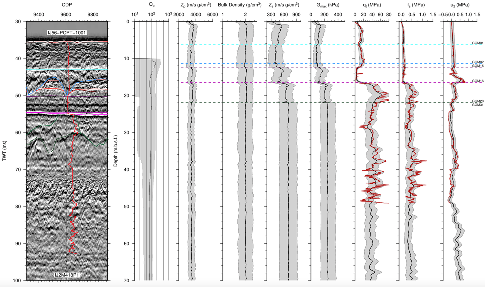
Integrating geotechnical data with geophysical datasets is a critical step in developing a reliable ground model for site investigations.
SAND provides support across all stages of the project cycle, offering expertise in building fully integrated, quantitative ground models that inform design risk assessment and engineering decisions.
Inversion and Seismic Attribution Analysis
Seismic inversion
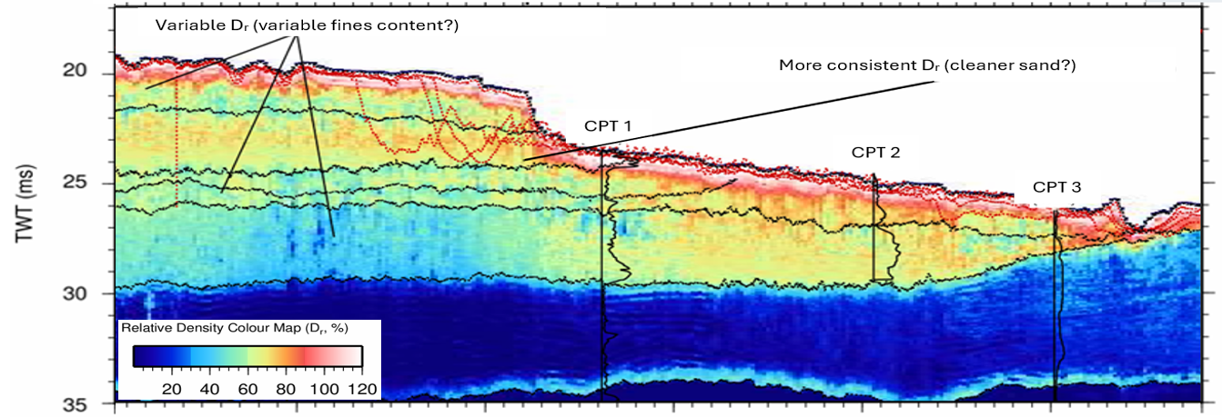
SAND offer a range of seismic inversion codes that use the amplitude, phase and frequency content of the seismic reflection data to derive quantitative information regarding the nature of the seabed and near-surface sediments. Depending on project requirements, we can provide insights into both bulk physical properties (e.g., P-wave velocity, bulk density, and porosity) as well as more advanced geotechnical properties (e.g., undrained shear strength, relative density, and soil classification) to be derived and mapped at a resolution controlled by the geophysical data.
Attribute Analysis
Seismic attributes are properties derived from the seismic trace using mathematical manipulation. This can include attributes that look at traces individually (such as instantaneous frequency) or collectively (such as structural dip).
SAND has developed workflows to combine relevant attributes together that identify key structural features in a semi-quantitative manner, highlighting often subtle facets in subsurface imagery. For example, identifying potential free gas migration pathways or using amplitude and frequency anomalies to identify potential layers containing gravel lag, or peat and organic-rich soils.
Inversion and Seismic Attribution Analysis
Interval velocities
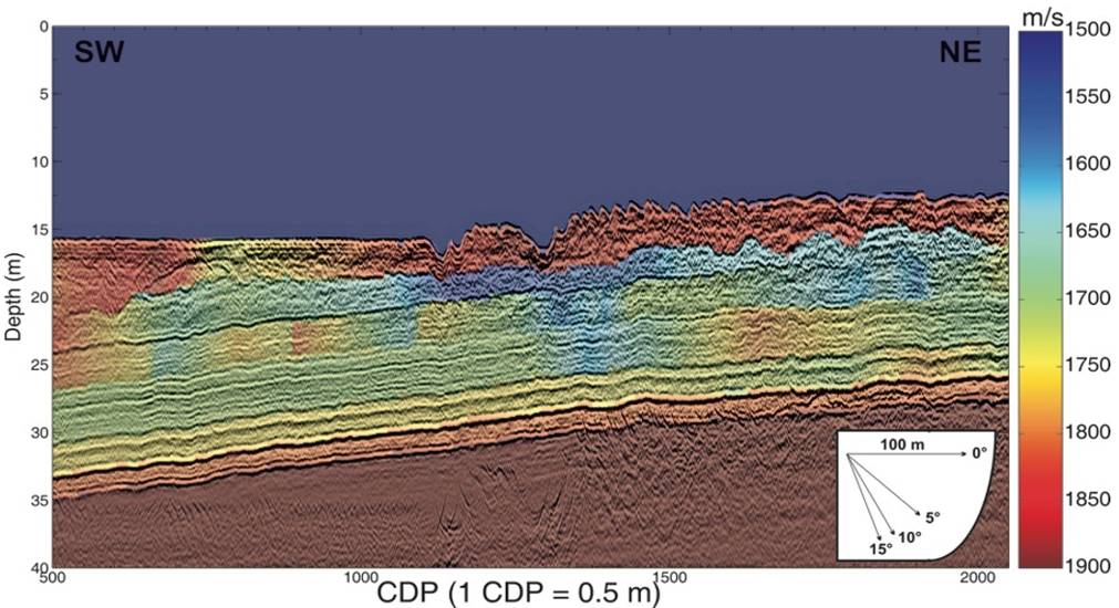
Acquisition of multi-offset seismic reflection data is now standard practice for most large offshore site surveys, offering improvements over single-channel data in both image quality and the ability to derive detailed subsurface velocity models. SAND have developed several algorithms and workflows specially designed to produce high quality interval velocity models from typical ultra-high-resolution seismic reflection data, permitting these data to be pre-stack depth migrated.
In addition to providing enhanced seismic images and presenting the data in the more useful depth-domain, high-resolution interval velocity models provide excellent sediment discrimination, supporting detailed geological and geotechnical interpretation.
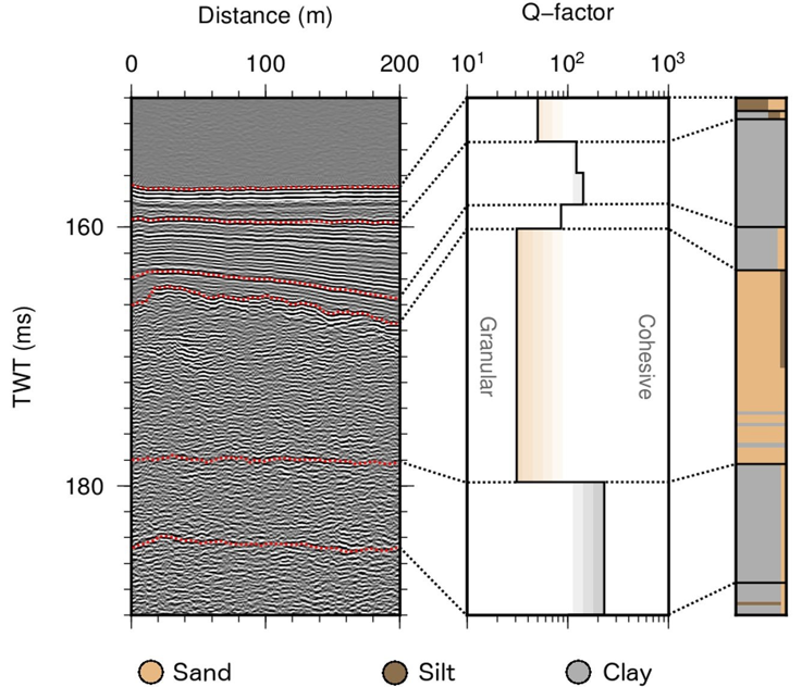
Q-factor Quantification
Q-factor quantifies seismic wavefield attenuation, representing the energy lost as seismic waves propagate through the subsurface. Q-factor has been shown to be strongly linked to the hydraulic permeability, allowing differentiation between cohesive and granular sediment behaviour. Q-factor analysis provides valuable information on the compressibility of near-surface sediments and can also offer estimates of gas saturation for shallow gas fronts.
Qualitive Interpretation
SAND has extensive experience in the interpretation of SBP, SUHRS and MUHRS seismic datasets to characterise the palaeoenvironment and develop geological ground models for site investigations.
Get in touch
Talk to us today about our work or your own project